The Future of Paper Charts
Will traditional paper charts soon be a thing of the past? And what will that mean for recreational boaters?
By Mark Bunzel
Last fall, the National Oceanic and Atmospheric Administration (NOAA), the source for official US government nautical charts, abruptly announced it would no longer distribute lithographic nautical charts as of April 2014. The printer of NOAA charts, the US Federal Aviation Administration (FAA), made the decision to stop printing charts after the US budget shutdown last September. Is this the beginning of the end of paper charts as we know them? Will printed charts from the Canadian Hydrographic Service (CHS) be next?
Ultimately, paper charts from all government sources will most likely go away. However, exactly when is not clear. The US government has been preparing to get out of the paper chart business for some time now. More than a decade ago, it licensed two companies to provide print-on-demand maps. Oceangrafix and East View Geospatial have both developed respectable businesses and provide a timely, high-quality print-on-demand product, available by mail and through their network of chart dealers.
Many customers decided long ago that print-on-demand charts were superior because they were high in quality, available on different paper stocks including waterproof, and included the most up-to-date information available on printing. Sales of traditional lithographic charts from NOAA have declined over the years.
Meantime, NOAA has kept its eye on the future, making new chart products available such as user-printable PDFs and Electronic Vector Charts (ENCs) or Raster Navigation Charts (RNCs). All are available for download over the Internet at no cost. The US considers chart data to be intellectual property belonging to the taxpayers who have already paid for it, and the right to acquire charts is open to anyone electronically at no charge.
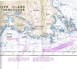
 In Canada, chart data is the copyright of the Crown and delivered through CHS. At this time, there are no plans to stop printing paper charts, but CHS officials have admitted that sales of paper charts have been declining. Today, CHS prints its 946 nautical charts primarily on-demand in Ontario. Some higher-volume charts are printed and inventoried using lithographic volume printing. The charts are then often air-shipped to dealers all over Canada and the US.
Charts and the Boater
The question is often asked, “Am I required to carry nautical paper charts by law as a recreational boater?” The short answer is no. As you will see in the excerpt of the Charts and Nautical Publications Regulations, 1995 (sidebar), there are two circumstances in which it is not necessary to carry paper charts:
• If the vessel is equipped with a big-ship Electronic Chart Display and Information System (ECDIS), and backup computers and power supply;
• If the master and owner of a boat less than 100 tons has adequate local knowledge.
Across Canada there is limited inspection or enforcement for charts. The risk is that if you are involved in a catastrophic or fatal accident, you as captain could be proven to have operated your vessel in an unsafe manner by not being aware of a well-charted obstacle because you did not have adequate navigation information, such as charts.
We are clearly in a changing time. Chartplotters, computers with marine navigation software and electronic charts, even low-cost tablets and iPads with $60 software, which includes data licensed from CHS, all could fulfill the requirement for adequate local knowledge of the surrounding waters.
The bigger issue for safe operation relates to how this new electronic information is used. The key for the prudent navigator is to view an area at the appropriate scale. To understand this, take a look at waters with known hazards on a chartplotter that is zoomed out. Rocks, reefs, shallows and other hazards may not appear. But zoom in and a route line that previously looked clear might now be seen to be strewn with rocks. In fact, to the navigator’s advantage, zooming in on a reliable, high-quality electronic chart may offer a clear view of hazards at a scale that is unavailable on any printed chart.
The point is that if you use electronic aids you still need to comply with the requirement to have the right navigational information at an appropriate scale – as you would with a paper chart. Before you stop using paper charts, make it a habit to review your routes at a large scale (zoomed in) so you see all obstructions, just as you would with a pencil line route on the appropriate-scaled paper chart for your cruise.
The bottom line is that new technology calls for new procedures and vigilance if you do choose to move on from tried and true paper charts.
Mark Bunzel is a nautical publisher and writer located in Nanaimo BC and Anacortes, Washington. He is editor and publisher of Ports and Passes and the Waggoner Cruising Guide for the Inside Passage, responsible for annual research on all marinas and anchorages between Olympia, Washington and Ketchikan, Alaska.
Charts and the Law – From the Canada Shipping Act, 2001 – Charts and Nautical Publications Regulations, 1995:
Carriage of Charts, Documents and Publications:
4. (1) Subject to subsection (2), the master and owner of every ship shall have on board, in respect of each area in which the ship is to be navigated, the most recent editions of the charts, documents and publications that are required to be used under sections 5 and 6. (2) The master and owner of a ship of less than 100 tons are not required to have on board the charts, documents and publications referred to in subsection (1) if the person in charge of navigation has sufficient knowledge of the following information, such that safe and efficient navigation in the area where the ship is to be navigated is not compromised:
(a) the location and character of charted
(i) shipping routes,
(ii) lights, buoys and marks, and
(iii) navigational hazards; and
(b) the prevailing navigational conditions, taking into account such factors as tides, currents, ice and weather patterns.
From the Canadian Hydrographic Service website:
All vessels in Canadian waters must carry and use nautical charts and related publications pursuant to the Canada Shipping Act, 2001, Charts and Nautical Publications Regulations, 1995, that are issued by, or on the authority of, the Canadian Hydrographic Service.
Photo
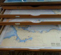
Photo 1: As more mariners rely on electronic charting systems, will printed charts – and chart lockers like this one at Vancouver’s Wright Mariner – fade from use?